

Fortæl dine venner om denne vare:
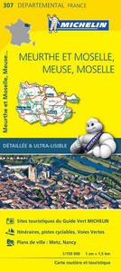
Michelin local Map: France blad 330: Cantal, Lozere
Michelin

Michelin local Map: France blad 330: Cantal, Lozere
Michelin
The MICHELIN Cantal, Lozere local map, scale 1/150,000 is the ideal companion to fully explore this northern part of France and provides star-rated Michelin tourist itineraries and attractions, as well as impressive 3D relief mapping. MICHELIN local maps are perfect for cyclist and outdoor enthusiasts with over 20 leisure symbols, extensive coverage of cycling paths and nature trails. With MICHELIN local maps, find more than just your way! - Impressive & realistic 3D relief mapping - Michelin selected itineraries and must-sees of the area - A clear and comprehensive key with 20 leisure symbols, as well as cycling paths and nature trails. - Star rated tourist sights and attractions cross referenced with the famous MICHELIN Green Guides. - Main cities plans and a comprehensive place name index
Målestok: 1:175.000 Serie: Michelin local Map Serienr.: 330
| Medie | Bøger Hardcover bog (Bog med hård ryg og stift omslag) |
| Udgivet | 5. april 2016 |
| ISBN13 | 9782067210486 |
| Forlag | Michelin |
| Genre | Maps & Guides |
| Mål | 115 × 250 × 8 mm · 500 g (Estimeret vægt) |
| Sprog | Engelsk |
Mere med Michelin


Andre har også købt
![Cover for Simon Ankjærgaard · Augustoprøret 1943 (Indbundet Bog) [1. udgave] (2020)](https://imusic.b-cdn.net/images/item/original/379/9788711983379.jpg?simon-ankjaergaard-2020-augustoproeret-1943-indbundet-bog&class=scaled&v=1599570193)
![Cover for Jakob Martin Strid · Den fantastiske bus (Indbundet Bog) [1. udgave] (2023)](https://imusic.b-cdn.net/images/item/original/098/9788702152098.jpg?jakob-martin-strid-2023-den-fantastiske-bus-indbundet-bog&class=scaled&v=1696053829)
![Cover for Tove Jansson · Billedhuggerens datter (Hæftet bog) [1. udgave] (2014)](https://imusic.b-cdn.net/images/item/original/561/9788702162561.jpg?tove-jansson-2014-billedhuggerens-datter-haeftet-bog&class=scaled&v=1410942970)
![Cover for Herbjørg Wassmo · Dina-trilogien: Karnas arv (Hæftet bog) [7. udgave] [Paperback] (2015)](https://imusic.b-cdn.net/images/item/original/206/9788711326206.jpg?herbjoerg-wassmo-2015-dina-trilogien-karnas-arv-haeftet-bog&class=scaled&v=1415700335)

![Cover for Camilla Biesbjerg Markussen · Skærekager deluxe (Indbundet Bog) [1. udgave] (2021)](https://imusic.b-cdn.net/images/item/original/905/9788794086905.jpg?camilla-biesbjerg-markussen-2021-skaerekager-deluxe-indbundet-bog&class=scaled&v=1631383695)
Se alt med Michelin ( f.eks. Kort , Paperback Bog , Bog , Hardcover bog og Hæftet bog )