
Fortæl dine venner om denne vare:
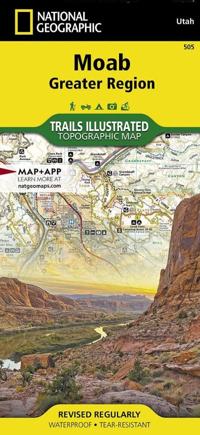
Moab Greater Region 2022nd edition
National Geographic Maps
Bestilles fra fjernlager

Moab Greater Region 2022nd edition
National Geographic Maps
- Waterproof - Tear-Resistant - Topographic Map
A premier destination for mountain biking, hiking, whitewater rafting, four-wheeling, and more, Moab offers adventure and recreation in one of the most iconic landscapes in the United States. National Geographic's Trails Illustrated maps of Moab were created in partnership with local land management agencies and adventure experts to provide unmatched detail of the area, with useful up-to-date information to guide and enrich your visit.
The Moab Greater Region map shows all of the major trail systems, public lands, and recreation sites in and around Moab. Particularly useful for motorized off-road vehicle use, it features 29 highlighted 4x4 trails, with trail segments labeled with mileage between intersections. The region's 10 major mountain bike trail areas are clearly mapped and labeled including Magnificent Seven, Rodeo, Navajo Rocks, Klondike Bluffs, Bar M (Moab Brands), Amasa Back, Klonzo, Sand Flats, Sovereign, and Whole Enchilada. The map includes all of Arches National Park and Dead Horse Point State Park, along with sections of Canyonlands National Park, Manti-La Sal National Forest, Bears Ears National Monument, Labyrinth Canyon Wilderness, and dozens of BLM Special Recreation Management Areas.
Trails are symbolized by use types, with trail difficulty listed for mountain bike and 4x4 trails. Trail system comparison charts are included for 4x4 and mountain bike areas to help choose areas to explore given time, skill, and equipment constraints. Colorado River access points and mileages are mapped and labeled for river recreation. Visitor centers, campgrounds, interpretive trails, and scenic overlooks are prominently mapped and labeled with their amenities. OHV, biker, and desert safety tips, laws, and etiquette are also provided.
Every Trails Illustrated map is printed on Backcountry Tough waterproof, tear-resistant paper. A full UTM grid is printed on the map to aid with GPS navigation.
Other features found on this map include: Colorado River, Green River, Dolores River, Hatch Point, La Sal Mountains, Mineral Point, Mount Peale, Salt Valley. Map Scale = 1:90,000Sheet Size = 37.75 x 25.5Folded Size = 4.25 x 9.25
2 pages, 2 Illustrations, unspecified
| Medie | Bøger Kort (Land- eller søkort) |
| Udgivet | 11. februar 2022 |
| ISBN13 | 9781566959001 |
| Forlag | National Geographic Maps |
| Antal sider | 2 |
| Mål | 95 g |
| Sprog | Engelsk |
Mere med National Geographic Maps
![Cover for National Geographic Maps · National Parks & National Forest of the Us [Map Pack Bundle] - National Geographic Destination Map (Kort) [2023rd edition] (2024)](https://imusic.b-cdn.net/images/item/original/452/9781566959452.jpg?national-geographic-maps-2024-national-parks-national-forest-of-the-us-map-pack-bundle-national-geographic-destination-map-kort&class=scaled&v=1713230308)
![Cover for National Geographic Maps · National Geographic Africa Map (Folded with Flags and Facts) - National Geographic Reference Map (Kort) [2022nd edition] (2024)](https://imusic.b-cdn.net/images/item/original/292/9781566959292.jpg?national-geographic-maps-2024-national-geographic-africa-map-folded-with-flags-and-facts-national-geographic-reference-map-kort&class=scaled&v=1713230295)
![Cover for National Geographic Maps · National Geographic North America Map (Folded with Flags and Facts) - National Geographic Reference Map (Kort) [2022nd edition] (2024)](https://imusic.b-cdn.net/images/item/original/339/9781566959339.jpg?national-geographic-maps-2024-national-geographic-north-america-map-folded-with-flags-and-facts-national-geographic-reference-map-kort&class=scaled&v=1713230295)
![Cover for National Geographic Maps · National Geographic South America and Antarctica Map (Folded with Flags and Facts) - National Geographic Reference Map (Kort) [2022nd edition] (2024)](https://imusic.b-cdn.net/images/item/original/346/9781566959346.jpg?national-geographic-maps-2024-national-geographic-south-america-and-antarctica-map-folded-with-flags-and-facts-national-geographic-reference-map-kort&class=scaled&v=1713230295)

![Cover for National Geographic Maps · Road Atlas: Scenic Drives Edition (united States, Canada, Mexico) (Kort) [2023rd edition] (2023)](https://imusic.b-cdn.net/images/item/original/069/9781566957069.jpg?national-geographic-maps-2023-road-atlas-scenic-drives-edition-united-states-canada-mexico-kort&class=scaled&v=1654624565)

![Cover for National Geographic Maps · Pennsylvania Guide Map (Kort) [2023rd edition] (2023)](https://imusic.b-cdn.net/images/item/original/977/9781566957977.jpg?national-geographic-maps-2023-pennsylvania-guide-map-kort&class=scaled&v=1714334936)

![Cover for National Geographic Maps · Road Atlas - Adventure Edition (Kort) [2024th Adventure edition] (2023)](https://imusic.b-cdn.net/images/item/original/890/9780792289890.jpg?national-geographic-maps-2023-road-atlas-adventure-edition-kort&class=scaled&v=1433670741)
![Cover for National Geographic Maps · Acadia National Park Day Hikes Map - National Geographic Topographic Map Guide (Kort) [2023rd edition] (2023)](https://imusic.b-cdn.net/images/item/original/100/9781566959100.jpg?national-geographic-maps-2023-acadia-national-park-day-hikes-map-national-geographic-topographic-map-guide-kort&class=scaled&v=1697947311)
![Cover for National Geographic Maps · World For Kids, The, Poster Sized, Laminated: Wall Maps World (Kort) [2019th edition] (2023)](https://imusic.b-cdn.net/images/item/original/962/9781597755962.jpg?national-geographic-maps-2023-world-for-kids-the-poster-sized-laminated-wall-maps-world-kort&class=scaled&v=1447624459)
![Cover for National Geographic Maps · Grand Canyon National Park Day Hikes Map - National Geographic Topographic Map Guide (Kort) [2023rd edition] (2023)](https://imusic.b-cdn.net/images/item/original/070/9781566959070.jpg?national-geographic-maps-2023-grand-canyon-national-park-day-hikes-map-national-geographic-topographic-map-guide-kort&class=scaled&v=1697947311)
![Cover for National Geographic Maps · Death Valley National Park Day Hikes Map - National Geographic Topographic Map Guide (Kort) [2023rd edition] (2023)](https://imusic.b-cdn.net/images/item/original/974/9781566958974.jpg?national-geographic-maps-2023-death-valley-national-park-day-hikes-map-national-geographic-topographic-map-guide-kort&class=scaled&v=1697947311)
![Cover for National Geographic Maps · Prague (Kort) [2023rd edition] (2023)](https://imusic.b-cdn.net/images/item/original/847/9781566957847.jpg?national-geographic-maps-2023-prague-kort&class=scaled&v=1608797569)
![Cover for National Geographic Maps · Sequoia / kings Canyon National Park: Trails Illustrated National Parks (Kort) [2023rd edition] (2023)](https://imusic.b-cdn.net/images/item/original/989/9781566952989.jpg?national-geographic-maps-2023-sequoia-kings-canyon-national-park-trails-illustrated-national-parks-kort&class=scaled&v=1400072548)
![Cover for National Geographic Maps · Northville-placid Trail, New York: Trails Illustrated National Parks (Kort) [2023rd edition] (2023)](https://imusic.b-cdn.net/images/item/original/211/9781597756211.jpg?national-geographic-maps-2023-northville-placid-trail-new-york-trails-illustrated-national-parks-kort&class=scaled&v=1668809812)

![Cover for National Geographic Maps · Utah National Parks [map Pack Bundle] Adventure Map (Kort) [2023rd edition] (2023)](https://imusic.b-cdn.net/images/item/original/979/9781597755979.jpg?national-geographic-maps-2023-utah-national-parks-map-pack-bundle-adventure-map-kort&class=scaled&v=1418025159)


![Cover for National Geographic Maps · United States, Southeastern Plains And Gulf Coast Adventure Map (Kort) [2023rd edition] (2023)](https://imusic.b-cdn.net/images/item/original/199/9781566957199.jpg?national-geographic-maps-2023-united-states-southeastern-plains-and-gulf-coast-adventure-map-kort&class=scaled&v=1635133424)
![Cover for National Geographic Maps · Yellowstone / grand Teton National Parks, Map Pack Bundle: Trails Illustrated National Parks (Kort) [2010th edition] (2023)](https://imusic.b-cdn.net/images/item/original/002/9781597754002.jpg?national-geographic-maps-2023-yellowstone-grand-teton-national-parks-map-pack-bundle-trails-illustrated-national-parks-kort&class=scaled&v=1418025165)
![Cover for National Geographic Maps · Flagstaff / sedona, Coconino & Kaibab National Forests: Trails Illustrated Other Rec. Areas (Kort) [2019th edition] (2023)](https://imusic.b-cdn.net/images/item/original/157/9781566955157.jpg?national-geographic-maps-2023-flagstaff-sedona-coconino-kaibab-national-forests-trails-illustrated-other-rec-areas-kort&class=scaled&v=1399554792)
Andre har også købt

Se alt med National Geographic Maps ( f.eks. Kort , Paperback Bog , Bog og Løsblad )